| SAC Bases:
Thule
Air Base |
|
 |
From 1953 to 1959, Thule's main mission was to function as an operations
base for SAC strategic bombers, supporting SAC B-36s, B-47s, and KC-97s. In
1957, SAC activated the 4083rd Strategic Wing at Thule,
consisting of B-36 bombers. During 1953, the US Army installed two 75mm and
four 90mm anti-aircraft guns in a ring around Thule, for air defense.
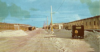
They didn't keep out the biggest enemy - winter.
Knud Rasmussen, a famous Danish explorer,
began the Danish Literary Expedition in this area in 1903-04. Rasmussen
returned to the area in 1906 and again in 1908 to begin a mission station in
the Thule area. In 1909 the ship Godthaab, anchored in North Star Bay, and
the first two buildings (a missionary and a storehouse) were built. The
Danish flag has since flown in the area.
In 1910, Rasmussen and his associate, Peter
Freuchen, came to the area to Cape York (Kap York Trading Post) Station. On
the suggestion of Freuchen, Rasmussen named the village, which grew up
around the post “Thule.” At that time, the area north of Mt Dundas, called
Uumanaq by the Greenlanders, was still inhabited. Freuchen became the first
trading post manager and held the position until 1920. The post served many
purposes, such as providing a base for scientific expeditions and providing
equipment and food for the native Greenlanders. The first Thule expedition
set out in 1912 across the ice cap to north Greenland and back. During the
second Thule expedition, 1916-18, Rasmussen mapped out the northernmost
coast of Greenland geographically, geologically, botanically, and
ethnologically. From 1919-24, three more expeditions took place. The fifth
expedition took Rasmussen on his famous great sled journey, traveling by dog
sled across Canada and Alaska to Siberia. |
|
Rasmussen returned to Thule each summer from 1926-1929. The station was now
growing. A hospital was built in 1928-29 and a pre-fabricated house, the Knud
Rasmussen House, was built in 1929 and was later used as a school. In 1929-30 a
Church was erected. In 1928 the Thule Law was born; it was signed by Knud
Rasmussen on 7 June 1929 and ratified by the Danish Government in 1931. The
Danish government took over the Thule district in 1931 and name Rasmussen to
represent the Danish state. In 1933, two settlements were found in the Thule
district, Siorapaluk in the north and Savigsivik in the south. Rasmussen died
that same year, and the Danish government took over his responsibilities.
On the anniversary of Germany’s occupation of Denmark, 9 April 1941, Danish
Ambassador Henrick Kauffman and Secretary of State Cordull Hull signed, “The
Agreement relating to the Defense of Greenland” in Washington. President
Roosevelt approved it on 7 Jun 1941. In the agreement, the US agreed to take
over the security of Greenland. After the attack on Pearl Harbor, the allies
established weather stations at Narssarssuaq airport, SonderStrom (Bluie
West-8), Ikateq (Bluie East-2), and Gronnedal (Bluie West-9). In 1943 the Army
Air Corp set up weather stations, Scoresbysund (bluie East-3) on the east coast
around the southern tip of Greenland, and Thule (Bluie West-6) to be operated by
Danish personnel. The weather stations gave the allies a strategic edge over
the Germans in battle planning and provided a decisive factor in D-Day. Based
on a good weather forecast from Greenland.
|
|
|
|
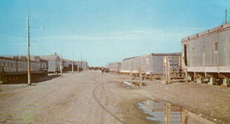
Winter |
General Eisenhower scheduled the landing in Normandy despite the strong winds in
the English Channel. Based on the Greenland weather reports, he knew the winds
would die the following day, so the Invasion was on!
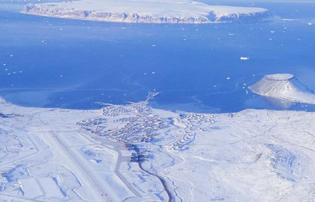
In 1946, a combined Danish-American radio and weather station was established in
the Royal Greenland Trade department Building at Pituffik (present day Thule air
Base). Pitiffuk is translated as “Place where they tie their boats.” By all
rights, Thule Air Base should have been named Pituffik Air Base after the
original site. The Navy built a new and much larger weather station. The Army
Corps of Engineers built a 4,000-foot airstrip on the south side of the valley.
In the following year the Thule airstrip was used as a jump-off point for
exploration and a supply point for construction of airstrips and weather
stations on the Canadian side of the straits (Eureka, Resolute, and Isachsen).
The first Transport Command aircraft landed on (September 1946. The East
Reconnaissance Group (Project Nanook) flew B-17 mapping and photography missions
from Thule’s primitive facilities. From 1946-50, several houses, a power plant,
a radio station, and a dirt runway were built at what is now called “Dundas
Village.” Dundas Village and the Inuit Village of Qaanaaq are protected by
Denmark and specifically excluded from areas under US Air Force control. In
1963 the area was given official status as the 17th municipality of
Greenland, the Thule municipality. The northernmost community in the world.
|
|
 |
|
Summer |
|
Construction of a worldwide system of modern air bases was one of the Air Forces
most important tasks following World War II. The US studied the possibility of
establishing a major operating base in Greenland when it became clear that round
trip flights of planes carrying atomic bombs between US or Canadian bases and
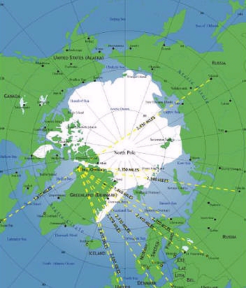
European objectives were impractical. The shortest route from the US to the
Soviet Union’s most important industrial areas was over the North Pole, and
Thule is at the precise midpoint between Moscow and New York. Thule became a
key point in the whole American military strategy. Strategic Air Command
bombers flying over the Arctic presented less risk of early warning than using
bases in England. Defensively, Thule could serve as a base for intercepting
bomber attacks along the northeastern approaches to Canada and the US.
A board of AF officers made a recommendation to pursue a base at Thule in
November 1950; it was subsequently supported by the Joint Chiefs of Staff and
approved by President Truman. To replace the agreement entered into during WWII
between the US and Denmark, a new agreement with respect to Greenland was
ratified on April 27, 1951 (effective on June 8, 1951). At the request of North
Atlantic Treaty Organization (NATO), the agreement became a part of the NATO
defense program. The pact specified that the two nations would arrange for the
use of facilities in Greenland by NATO forces in defense of the NATO area known
as the Greenland Defense Area.
Thule AB was constructed in secret under the code name Operation BLUE JAY.
Construction for Thule AB began in 1951 and was completed in 1953. The
construction of Thule is said to have been comparable in scale to the enormous
effort required to build the Panama Canal. The Navy transported the bulk of
men, supplies, and equipment from the naval shipyards in Norfolk, VA. On June
6, 1951 an armada of 120 shipments sailed from Norfolk, VA. On board were
12,000 men and 300,000 tons of cargo. They arrived Thule on July 9, 1951.
Construction took place around the clock. The workers lived on-board the ship
until quarters were built. Once they moved into the quarters, the ships
returned home.
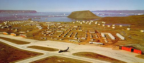
The base was initially designed as a forward base for staging SAC bombers and
tankers. It was designed and built to house 12,000 personnel (during the peak
period it housed approximately 10,000 with personnel living at Camp Tuto, BMEWS/J-Site,
Camp Century, P-Mountain, in Nike Sites, and at Cape Atholl). It was built with
a 10,000-foot (by 200’) runway and a fuel storage capacity of about 100 million
gallons (the largest in DOD—built to support mid-air refueling of the B-47
bombers). The agreement set aside 339,000 acres, and when Thule was first
built, this is how it looked: main base 2600 acres, 82 miles of road, 38 fuel
tanks, 10 hangers (6 are 28,000 sq. feet), 122 barracks, 6 mess halls, a gym,
service club, Officers’ club, hobby shop, library, base exchange, post office,
theater, chapel, and hospital. There were also 63 warehouses, a laundry, a
bakery, two primary power plants, and 4 auxiliary power/heating plants.
|
 |
 |
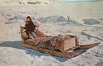
| Local Resident |
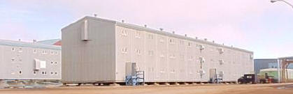
Barracks |
|
|
Buildings were built using Arctic (Clements) panels. These large panels were
used commercially in the 1950s to build large walk-in refrigerators. So, in
essence we are living in refrigerator boxes, but instead of keeping the contents
cold they actually keep us warm. In addition to the building structure the
engineers had to devise a plan to build the structures on the permafrost. The
new buildings were going to be heated and would melt the permafrost. If that
happened then the buildings would sink. So, the engineers constructed the
current buildings on pilings. The pilings allowed the air to circulate under the
buildings and remove the heat from the structure. This prevented the buildings
from sinking. Most buildings were built in 60 days in 1951.
The 1000-foot pier (Delong Pier) was constructed from 8 barges towed from the
Gulf of Mexico placed on caissons and stabilized alongside a rock-filled
causeway.
On August 18, 1951, the new airstrip was inaugurated with a visit from the Air
Force Chief of Staff General Hoyt S. Vandenberg. Operation Blue Jay was
completed in a short 104 days. On October 23rd, the last
construction crews left Thule but 400 men were left behind as a caretaker force
through the winter of 1951/52. The next spring a major part of the workforce
returned to expand the base. In November 1952, when the Air Force took control,
Thule was considered operational. By fall 1953 the bulk of the construction was
complete.
On July 1, 1951, the 6622nd AB Squadron of the Northeast Air Command
arrived and air operations commenced on September 11, 1951. The first fighter
interceptors assigned to Thule were four F-9Abs and began operations on
September 11, 1952.
In 1957, Air Defense Command took control of the base and initiated the 74th
Fighter Interceptor Squadron (FIS). The FIS was deactivated in March 1960
leaving Thule without interceptor protection for the first time since September
1952. The Joint Chiefs of Staff rescinded this deactivation in June 1960, and
the 332 FIS was assigned to Thule in August 1960. They flew supersonic,
all-weather F-102 Delta Daggers.
In 1957 and 1958 four Army Nike Defense system Batteries were constructed (two
on North Mountain and two on South Mountain) under the code-name “Rising Star.”
These Surface to Air missiles (SAMs) were linked together with the air
interceptors and a control and warning system. Each location had two areas:
launch and control. They were closed down in July 1960. Battery A was
demolished in 1990, but two buildings still stand at A launch located at Dundas
Village. Battery B was demolished on an undetermined date, and the debris at
the launch site was pushed into the underground silos. Battery C is still
largely intact. It probably represents the best remaining example at Thule.
The barracks and mess hall still stand, but the storeroom is gone. The three
launch structures are still intact. One stairwell, a soldiers’ artwork still
survives. It is the depiction of a goose and refers to the Goose Air Defense
Sector to which the battery belonged. C Control has been demolished. All that
remains is the concrete bases of the radar. Battery D, D Launch is located on
South Mountain, overlooking North Star Bay; the launch structures are still
intact as is the watchtower.
In 1958 and 1959 additional construction consisted of five new barracks, a
dining facility, the airmen’s club, two BOQs, a technical library, and two
warehouses. In 1959 and 1960 the base common water and sewage distribution
mains were constructed. Up to that point all water delivery and sewage pickup
was accomplished by truck! In 1960 the over-the-road, heated, and insulated
pipeline system was completed. Replacement value of buildings was valued at
over $2 billion.
The base activated as a part of the Northeast Air Command (NEAC) in January 1952
and transferred to SAC in 1957. On July 1, 1960 the ADC officially assumed
command at Thule. By 1960, the addition of long-range aircraft to the SAC
inventory eliminated the need for Thule to operate as a forward support base,
and the mission turned from a SAC forward operations base to air defense.
In 1961, a Ballistic Missile Early Warning System (BMEWS) radar was constructed
at J Site, 13 miles north east of the base. BMEWS was developed by the Raytheon
Corporation in order to provide North America warning of a transpolar missile
attack from the Russian mainland and submarine-launched missiles from the Arctic
and North Atlantic Oceans. The four fixed antenna, 400 feet long and more than
300 feet high, were larger than a football field turned upright. It was during
this period that Thule reached its maximum manning, about 10,000 personnel.
Starting in July 1965, there was a general downsizing of activities at Thule.
The host units, the 4683rd Air wing, along with the 332d Fighter Interceptor
Squadron, were deactivated. In January 1968, the population of Thule was 3,370.
The old mechanical BMEWS radar was upgraded to a solid-state, phased-array
system in June 1987 to make the operation more effective and efficient.
Information from this site is transmitted to the North American Aerospace
Defense (NORAD) Command Post at Cheyenne Mountain, CO. Information is then
passed to National Command Authorities.
Another Thule mission dates back to 1961 when the air Force established a
satellite command and control facility (OL-5) to track and communicate with US
satellites in polar orbit. Now known as Det 3, it is part of the Air Force
Space Command worldwide satellite command and control network. Det 3 is one of
nine worldwide satellite tracking stations and constitutes the common user
portion of the Air Force Satellite Control Network (AFSCN). This network
directly supports space operations by providing telemetry tracking and
commanding to satellites developed and deployed by DOD, other US government
agencies, and allied governments. It also provides data distribution and
routing systems to support external users programs and other ground elements.
Because
of its northern location, Thule also provides support to a wide range of
logistical resupply operations and arctic scientific studies. Whether it’s
missile warning, satellite control, aviation support, or arctic studies, Thule
plays a key role in America’s national security.
In 1982, Thule became an Air Force Space Command base. As you can see, the
mission has changed from one of SAC alert to the primary mission of supporting
BMEWS. Thule also provides logistical support to Station Nord, CFS Alert, and
CFS Eureka.
In the spring of 1953 the Greenlandic Village of Thule, located at the base of
Mt Dundas, was moved 65 miles north to Qaanaaq, on Red Cliff Peninsula. The
Inuits said that the noise and smells from the planes and ships frightened away
the walruses, seals, polar bears, and birds essential to their cultural
survival. They moved so that hunting and fishing could continue without
disturbances from the activities of the modern air base. Before the air base at
Thule was built, the Inuits used the top of Mt Dundas as a burial ground. The
remains of the Danish explorer Knud Rasmussen (1879-1933) use to lie there until
being returned to Denmark in the 1990s. Upon departing, the people of Thule
demanded they take the name with them. The settlement remained but adopted the
name Dundas, taken from the nearby mountain. In 1985, Dundas Village, at the
base of Mt Dundas, closed down.
|
|
|
|